
02 Apr Form-based Codes: Replacing the everyday American City with the ‘Ideal Communist City’
Form-Based Code
/fôrm-bāsed kōd/
noun
A form-based code is a land development regulation that fosters predictable built results and a high-quality public realm by using physical form (rather than separation of uses) as the organizing principle for the code. A form-based code is a regulation, not a mere guideline, adopted into city, town, or county law. A form-based code offers a powerful alternative to conventional zoning regulation.
Several years ago, I wrote a series of articles for News with Views, explaining Sustainable Development. Today two of them are popping up regularly in the media. Back when I wrote these two articles, people would not believe that all this planning and organizing could have been dreamed up by the Power Elite, let along set down as part of the blueprint for Agenda 21.
Read that definition above of Form-based Code again. Note: “a regulation, not a mere guideline for every city, town, or county”. And “a powerful alternative to conventional zoning regulation”. You be it is. The only good I can see from this is that we can get rid of 90% of the staff on our planning commissions – everything will be spelled out for us by the Power Elite. There will be no exceptions.
Today, A Southern California county put the finishing touches on a first-of-its-kind wildlife corridor Tuesday that will protect important pathways for animals to pass between critical habitats and into Los Padres National Forest. This is part of the Wildlands Project. “The main aim is to provide restrictions on development to provide adequate pathways for wildlife to pass through rural and semirural parts of Ventura County. Guidelines under the new zoning ordinance include restrictions on outdoor lighting, fencing and other development that could hinder animals. Waterways will also gain a 200-foot buffer to protect animals from human incursion.” (boldface mine.) Straight out of the Wildlands Project.
- Then there is this from Tom DeWeese: Chicago, Illinois: So-called “affordable housing” advocates have filed a federal complaint against the longtime tradition of allowing City Aldermen veto power over most development proposals in their wards, charging that it promotes discrimination by keeping low-income minorities from moving into affluent white neighborhoods. Essentially the complaint seeks to remove the Aldermen’s ability to represent their own constituents.
- Baltimore, Maryland: The NAACP filed a suit against the city charging that Section 8 public housing causes ghettos because they are all put into the same areas of town. They won the suit and now the city must spend millions of dollars to move such housing into more affluent neighborhoods. In addition, landlords are no longer permitted to ask potential tenants if they can afford the rent on their properties.
- Oregon: Speaker of the Oregon House of Representatives Tina Kotek (D-Portland) is drafting legislation that would end single-family zoning in cities of 10,000 or more. She claims there is a housing shortage crisis and that economic and racial segregation are caused by zoning restrictions.
Where does this come from?
AGENDA 21: THE END OF WESTERN CIVILIZATION
PART 6
By Kathleen Marquardt
June 27, 2012
NewsWithViews.com
Part 6 The Transect
“In a time of universal deceit – telling the truth is a revolutionary act.” “Political language . . . is designed to make lies sound truthful and murder respectable, and to give an appearance of solidity to pure wind.” -George Orwell, author and Fabian Socialist
In my article, “Incrementalism, Regionalism and Revolution,” I briefly touched on planning and quoted from author, Jo Hindman. She will again help me explain what is happening vis a vis Urban Renewal and metro-planning. From her book, Blame Metro, we read, “Much is written about the incognito warfare on United States soil which public officials and their accomplices are waging to wrest private property from landowners. The strategy is to make property ownership so unbearable by harassment through building inspections, remodeling orders, fines and jailings, that owners give up in despair and sell to land redevelopers at cut-rate prices. Positive municipal codes are the weapons in the warfare.”[1]
Note, Hindman wrote that in 1966, yet it fully applies to today’s attacks on private property; many of the same strategies are being used, they just “changed the names to protect the guilty.”
Hindman writes, “‘Strengthening county government’ is a hackneyed Metro phrase indicating that the Metro take-over has begun. . .. Planning assistance subsidized by Federal money leads small cities and counties into direct obedience under a regional master plan. Land use rights are literally stolen (ital. mine) from landowners when zoning is applied to land.”[2]
In 1949, the Communitarian forebears of today’s planners wrote the original plans that were designed to free us of our property under the National Housing Act. Back then it was the American Society of Planning Officials,[3]the American Institute of Planners, and the National Planning Association. Today it is the American Planning Association (APA), which was formed in 1978 by combining the American Institute of Planners and the Society of Planning Officials. As you can see by their footnote, the APA brags that they were meddling in our private affairs since 1909, in fact here are the exact words, “On May 21-22, 1909, 43 planners met in Washington, D.C., at the first National Planning Conference. This event is considered to be the birth of the planning movement in America.” A sad day for the American Republic.
Mimicking today’s ICLEI V.P. Harvey Ruvin, the 60s’ American Institute of Planners “makes no bones about its socialist stance regarding land; its constitution states AIP’s ‘particular sphere of activity shall be the planning of the unified development of urban communities and their environs and of states, regions, and the nation as expressed through determination of the comprehensive arrangement of land uses and land occupancy and the regulation thereof.[4] . . .The present-day crew of planners, drawing no line between public and private property, believe that land-use control should be vested in government and that public planners should have sole right to control the use of all land.”[5]
That is not just similar to what is going on today; that is exactly what is happening. Why? Because the sons, daughters and cronies of the puppeteers that were pulling the strings back in the beginning and middle of the 20th Century are pulling the strings of today’s planners. We just have a new generation of the same treacherous, thieving scheme updated with new-fangled, high-tech sounding names for the same old land (and people) control mechanisms.
THE TRANSECT
A 2002 APA Journal article gives the original meaning of transect as: a cut or path through part of the environment showing a range of different habitats. Biologists and ecologists use transects to study the many symbiotic elements that contribute to habitats where certain plants and animals thrive.
Planners took that technique, one that was designed for studying flora and fauna, and tweaked it to apply to humans. I would say the tweak was more a wrenching, actually it is more in the line of suspending critical thinking to superimpose the artificial and nonsensical process of the transect on humans and their mobilization.
Under the biological study, a transect shows where certain flora and fauna thrive, exist somewhat readily, or barely subsist in the different habitats from (get description i.e., arctic to tropical). With great literary(?) license, planners take the definition of biologic transect and, like Oliver Stone, rewrites history, these planners are rewriting biology; they want to play an active role in the phylogeny of homo sapiens, in fact they want to devolve it. One of the problems here is that their fairy tale is being used to take property rights (and thus liberty) from man and make him a slave. Laws should not be based upon make-believe. Yet this country, no the entire world, is being redesigned using Communitarians’ far-fetched, pseudo-utopian desires to sate the global elites’ desire to control the entire globe.
Look at their definition of transect for people and land planning: “Human beings also thrive in different habitats. Some people prefer urban centers and would suffer in a rural place, while others thrive in the rural or suburban zones. Before the automobile, American development patterns were walkable, and transects within towns and city neighborhoods revealed areas that were less urban and more urban in character. This urbanism could be analyzed as natural transects are analyzed.”[Link]
To compare humans in differing habitats with flora or fauna is preposterous hubris, and especially because the planners are using apples and oranges: “some people prefer urban centers and would suffer in a rural place,” does not mean the same thing as the biology transect means. The suffering would be a mental fabrication and would be such that to call it suffering in the same sense as plants or animals outside their natural habitat is absurd.
The planners also extol the virtues of the time before the automobile, “American development patterns were walkable, and transects within towns and city neighborhoods revealed areas that were less urban and more urban in character. This urbanism could be analyzed as natural transects are analyzed.” As if what we have today is “unnatural.” What these planners keep forgetting (and want us to forget also) is that we humans are part of nature and thus what we are and what we do is natural. Unlike other animals, we humans have a moral and cognitive brain. Our brain is what provides us with the necessary tools we need to survive and prosper, and one of those tools is the automobile.
So we have a convoluted, computer-modeled construct of what the entire ecosystem of the world should be and is called the Transect. But as with everything else in this New World Order NewSpeak, that really isn’t the truth. No, they did not sit down with the details of biological transect and translate it via computer modeling to a human/development version. What they did was take The Ideal Communist City[6] and figured out how to sell it to the American public by superimposing it over their Transect model.
The APA describes the Transect as “a geographical cross-section of a region used to reveal a sequence of environments. For human environments, this cross-section can be used to identify urban character, a continuum that ranges from rural to urban. In transect planning, this range of environments is the basis for organizing the components of the built world: building, lot, land use, street, and all of the other physical elements of the human habitat.[7] Pay close attention to that last sentence, “the basis for organizing the components of the built world.” In my understanding of English, that means telling us where each component of our lives goes; we don’t get to choose where we build our homes unless they in the area designated by planners. I am not misreading that because that same sentence continues, “building, lot, land use, street, and all of the other physical elements of the human habitat(ital. mine).” Sounds fairly simple to me, we will be told what and where we may build or even if we may build, and how we will live in that habitat.
To continue from the APA article, “In transect planning, the essential task is to find the main qualities of immersive environments,[8] …. Once these are discovered, transect planning principles are applied to rectify the inappropriate intermixing of rural and urban elements — better known as sprawl. This is done by eliminating the ‘urbanizing of the rural’. . . or, equally damaging, the ‘ruralizing of the urban’.
into discrete categories. This approach is also dictated by the requirement that human habitats fit within the language of our current approach to land regulation (i.e., zoning).”[9]
The discrete categories of the transect continuum run from Rural Preserve, Rural Reserve, Sub-Urban, General Urban, Urban Center to Urban Core. Understand that the Rural Preserve is the Wildlands, the area humans will be forbidden to enter, and the Rural Reserve will be the connecting corridors to the Reserve area, i.e., corridors for fauna movement and human use will be highly restricted.
Remember, as I pointed out at the beginning of this article, the Communitarians, or global elites, introduced the zoning and planning systems used in this country. Now that they have gotten the American public inured to “planning,” they want to move us to the next step — where they plan every aspect of our lives through planning. To do so, they have to pretend that the original zones and plans came from us, the people, so they can say they need to throw the old ones out and introduce a whole new system. We are told, “The most important obstacle to overcome is the restrictive and incorrect zoning codes currently in force in most municipalities. Current codes do not allow New Urbanism to be built, but do allow sprawl. Adopting a TND ordinance and/or a system of ‘smart codes’ allows New Urbanism to be built easily without having to rewrite existing codes.”
If you go to the link above, you will see that New Urbanism (transect planning plus) deals with everything but property rights. (Actually property rights are verboten in this not-so-brave new world they are bringing us, so they ignore them because property rights will not exist in the not to distant future if we do not put a stop to this.) It is Sustainable Development written in capitals and boldface. And how do they plan on doing this? The most effective way to implement New Urbanism is to plan for it, and write it into zoning and development codes. This directs all future development into this form.
Note: “directs all future development into this form.”
The new planning codes they want: Smart Codes. What are they?
Footnotes:
1. Hindman, Jo, Blame Metro, Caxton Press, 1966, p. 21.
2. Ibid. p.80.
3. Within APA would be a professional institute — the American Institute of Certified Planners — that would be responsible for the national certification of professional planners. “Although AIP was incorporated in 1917 (as the American City Planning Institute, renamed the American Institute of Planners in 1939), and ASPO in 1934, we actually trace our roots further back to 1909 and the first National Conference on City Planning in Washington, D.C. From that and subsequent conferences, the organized planning movement emerged, first through our two predecessors and, since 1978, through APA.” (from APA website)
4. AIP Constitution (1960).
5. Hindman, Blame Metro, p.116.
6. Baburov, et al, The Ideal Communist City, i Press Series on the human environment, 1968.
7. “Transect Planning,” Duany, Andres and Emily Talen. APA Journal, Summer 2002, Vol. 68, No. 3, p.245.
8. a term borrowed from “the notion of virtual reality. . .. When these virtual environments are successful, they are said to be immersive — virtual models that function as if they were actual environments.”
9. Ibid, p.247.
AGENDA 21: THE END OF WESTERN CIVILIZATION
PART 7
The Smart Code
[Note: Part 6, “The Transect,” should be read before reading this article to get full understanding of SmartCode.]
One of the most fundamental requirements of a capitalist economic system—and one of the most misunderstood concepts—is a strong system of property rights. For decades social critics in the United States and throughout the Western world have complained that “property” rights too often take precedence over “human” rights, with the result that people are treated unequally and have unequal opportunities. Inequality exists in any society. But the purported conflict between property rights and human rights is a mirage. Property rights are human rights. –Arman Alchian
“The SmartCode is a form-based code that incorporates Smart Growth and New Urbanism principles. It is a unified development ordinance, addressing development at all scales of design, from regional planning on down to the building signage. It is based on the rural-to-urban transect rather than separated-use zoning, thereby able to integrate a full range of environmental techniques. Because the SmartCode envisions intentional outcomes based on known patterns of urban design, it is a more succinct and efficient document than most conventional codes.“ (To download SmartCode, go down to smartcode version 9.2 and click on it.)
The American Planning Association brags that their “definition emphasizes comprehensive planning that results in a unique sense of community and place, preservation of natural and cultural resources, of the expansion of transportation and housing choices beyond what we have now and we also emphasize the promotion of public health and healthy communities, which is an issue that has just begun to surface over the past two years.”[1]Understand that the “transportation and housing choices beyond what we have now” refer to walking, biking, rail and stack-em and pack-em housing. We have all those means of transportation now but we are not utilizing them as the APA and other Sustainable Development proponents would like because they are either expensive, impractical or unappealing to us. There is stack-em and pack-em housing already in large cities and in slum areas. Right now, most people chose what kind of housing they want and many chose single family homes in suburban (aka sprawl in Greenspeak) and rural areas — anathema to Smart Growth promoters. Also we want to retain our individual freedom which would negate being forced into communal housing with the associated communal living requirements of Smart Growth.
You may notice that they (Sustainablists, Commutarians) keep touting that people are moving from the rural and suburban areas into the cities at great rates “because they want the infrastructure and amenities available there.” I am not sure that people are moving into cities (yet) in any great numbers, but those groups, let’s call them Sustainablists, not only want to drive people into the cities (so they can be more easily controlled), and they are writing the planning to do just that. Looking at areas around the country, they are succeeding because they have established planning commissions in every city, town and county.
“The SmartCode is a form-based code, meaning it envisions and encourages a certain physical outcome — the form of the region, community, block, and/or building. Form-based codes are fundamentally different from conventional codes that are based primarily on use and statistics — none of which envision or require any particular physical outcome.”[2] Right, conventional codes, the codes used now, do not require all buildings, streets and towns to look alike.
“The SmartCode is a tool that guides the form of the built environment in order to create and protect development patterns that are compact, walkable, and mixed use. These traditional neighborhood patterns tend to be stimulating, safe, and ecologically sustainable. The SmartCode requires a mix of uses within walking distance of dwellings, so residents aren’t forced to drive everywhere. It supports a connected network to relieve traffic congestion. At the same time, it preserves open lands, as it operates at the scale of the region as well as the community.”[3] Go back and look closely at what was said: “. . . guides the form of the built environment, . . .” just as I said above, they are making all buildings the same.
And remember, in Part 6, The Transect, I quoted the the APA , “In transect planning, this range of environments is the basis for organizing the components of the built world: building, lot, land use, street, and all of the other physical elements of the human habitat. (emphasis mine)”[4]
Transfer of Development Rights (TDR)
“Local governments use TDR programs to mitigate the economic impact of land use regulations, specifically to compensate landowners for perceived partial takings (Johnston and Madison, 1997). This planning tool offers landowners a way to recapture some lost economic value when a property is downzoned[1] from residential use to agricultural use for preservation purposes.” Note the two phrases: “to compensate landowners for perceived partial takings” and “to recapture some lost economic value when a property is downzoned.” They are inferring that takings are a figment of the property owners’ imaginations and with the “recapture of some lost value” admitting that they are not going to compensate owners with the full value of their property.
Some of the things the SmartCode does:
- “It utilizes a type of zoning category that ranges systematically from the wilderness to the urban core.”[5]In other words, it encompasses the entire land mass.
• “It enables and qualifies Smart Growth community patterns that include Clustered Land Development (CLD), Traditional Neighborhood Development (TNDTM), Regional Center Development (RCD), and Transit-Oriented Development (TOD).”[6]
• “It integrates the scale of planning concern from the regional through the community scale, on down to the individual lot and, if desired, its architectural elements.”[7] In other words, every aspect of development and they want to chose your appliances also.
• “It integrates methods of environmental protection, open space conservation and water quality control.
• “It integrates subdivision, public works and Transfer of Development Rights(TDR) standards.
• “It encourages specific outcomes through incentives, rather than through prohibitions.”[8] The intention is to make using SmartCode easy and standard codes difficult so that people are inclined to take the path of least resistance — not realizing what it means for property rights and individual freedom. “Encouraging specific outcomes” should scare the devil out of you. Why would they want specific outcomes for every person in America?
As I noted near the beginning of this article the APA brags that their “definition emphasizes comprehensive planning that results in a unique sense of community and place, preservation of natural and cultural resources, of the expansion of transportation and housing choices beyond what we have now and we also emphasize the promotion of public health and healthy communities, which is an issue that has just begun to surface. . . .” What the meaning is that humans will no longer own their own homes instead we will be herded into the “unique sense of community and place” which is the stack-em and pack-em Smart Growth communal habitats. The healthy communities are Commutarian, Sustainablist versions of healthy, but healthy for whom? Not for individuals who believe in free will, individual freedom and the right to private property. In these new “healthy communities” you will be told what is healthy and what is not and you will not be given the choice of deciding for yourself if you want to follow the leader. You think Bloomberg’s soda ban is draconian, just wait.
In Part 8 I will go deeper into SmartCode.
Footnotes:
1. American Institute of Certified Planners, Green Infrastructure, “Smart Growth Codes,” Transcript p5, January 21, 2004.
2.Center for Applied Transect Studies, SmartCode, p V.
3. Ibid
4. “Transect Planning,” Duany, Andres and Emily Talen. APA Journal, Summer 2002, Vol. 68, No. 3, p.245.
5. Center for Applied Transect Studies, SmartCode, p VIII
6. Ibid
7. Ibid
8. Ibid
AGENDA 21: THE END OF WESTERN CIVILIZATION
PART 8
By Kathleen Marquardt
October 2, 2012
NewsWithViews.com
Much is written about the international cold war, but little about the incognito warfare on United States soil which public officials and their accomplices are waging to wrest private property from landowners. Jo Hindman, 1972, Blame Metro, p31.
Objectives
10.5 The broad objective is to facilitate allocation of land to the uses that provide the greatest sustainable benefits and to promote the transition to a sustainable and integrated management of land resources. In doing so, environmental, social and economic issues should be taken into consideration. In more specific terms, the objectives are as follows:
(a) To review and develop policies to support the best possible use of land and the sustainable management of land resources by not later than 1996. Agenda 21, Earth Summit, p.85
Today (1995), some 70 years after (Herbert) Hoover‘s committee drafted the standard acts,[1] another, similar effort is taking place: the American Planning Association’s GrowingSmart project.[2]
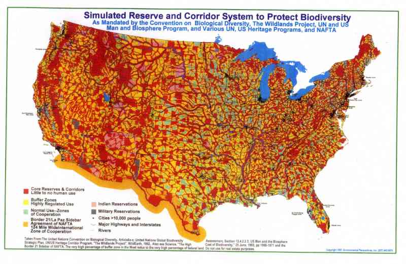
In Part 6, I discussed the Transect which is a system to divide the land of our country (and the world) into the Wildlands devised by Arne Noss (deep ecologist) and Dave Foreman (radical environmentalist), but under deceptive, seductive names. You can read how a New Urbanism posted story titled “Transect applied to regional plans,” describes it:
“The Transect has six zones, moving from rural to urban. It begins with two that are entirely rural in character: Rural preserve (protected areas in perpetuity); and Rural reserve (areas of high environmental or scenic quality that are not currently preserved, but perhaps should be). The transition zone between countryside and town is called the Edge, which encompasses the most rural part of the neighborhood, and the countryside just beyond. The Edge is primarily single family homes. Although Edge is the most purely residential zone, it can have some mixed-use, such as civic buildings (schools are particularly appropriate for the Edge). Next is General, the largest zone in most neighborhoods. General is primarily residential, but more urban in character (somewhat higher density with a mix of housing types and a slightly greater mix of uses allowed).
At the urban end of the spectrum are two zones which are primarily mixed use: Center (this can be a small neighborhood center or a larger town center, the latter serving more than one neighborhood); and Core (serving the region — typically a central business district). Core is the most urban zone.” (ital. mine)
Michael Coffman’s Wildlands Map, calls the zones by different names (protected instead of rural preserved, corridors for rural reserve, etc) but the results are the same: people in cages and animals having the run of the country, with 50% of American land off limits to humans.
How is all this to be done? According to Agenda 21, by “Promoting application of appropriate tools for planning and management
10.8 Governments at the appropriate level, with the support of national and international organizations, should promote the improvement, further development and widespread application of planning and management tools that facilitate an integrated and sustainable approach to land and resources.” One of the tools, of course, is SmartCode.
SmartCode is defined in a pamphlet of 72 pages; there is no way all of it can summarize all of it in this article but I am going to give some highlights (?) (in ital) with page numbers so you can look them up with the accompanying information:
- The provisions of this Code, when in conflict, shall take precedence over those of other codes, ordinances, regulations and standards except the local health and safety codes. p2 In other words, this code is to be the law of the land, both literally and figuratively.
- INTENT
The Region a. that the region should retain its natural infrastructure and visual character derived from topography, woodlands, farmlands, riparian corridors and coastlines. b. that growth strategies should encourage Infill and redevelopment in parity with new communities. p2 In real terms, build in the cities (up when you can’t go out), but have the rest of the area as pristine as possible, no matter how many homes you have to raze.
The Community
- that neighborhoods and regional centers should be compact, pedestrian-oriented[3] and Mixed use.
- that neighborhoods and regional centers should be the preferred pattern of development and that Districts specializing in a single use should be the exception.
- that ordinary activities of daily living should occur within walking distance of most dwellings, allowing independence to those who do not drive.Think about how cities like Knoxville, Los Angeles, even Bethesda, MD, will have to be almost totally redeveloped to achieve this goal. The costs will be astronomical. (Consider also the psychological cost of everyone having to live identically to everyone else.)
- that the region should include a framework of transit, pedestrian, and bicycle systems that provide alternatives to the automobile.
The Block and the Building
- that civic buildings should be distinctive and appropriate to a role more important than the other buildings that constitute the fabric of the city.Reminiscent of Nazi German: government is the most important entity thus their buildings should reflect that sentiment.
- that the harmonious and orderly evolution of urban areas should be secured through form-based codes. p3 I recommend that you check out The Ideal Communist City by Alexei Gutnov et al. to see what is envisioned to replace our often beautiful, sometimes eclectic cities and towns; harmonious and orderly means cookie-cutter, stack-em and pack-em buildings with zero personality. Forget gingerbread, forget picture windows; even a Potempkin Village is out of the realm of our new reality.
- that the transect Zone descriptions on table 1 shall constitute the intent of this code with regard to the general character of each of these environments. p4.
TAKE NOTE
- twenty years after the approval of a regulating plan, each transect Zone, except the t1 natural and t2 rural Zones, shall be automatically rezoned to the successional (next higher) transect Zone, unless denied in public hearing by the legislative body. p 5. Read that closely; after 20 years of Sustainable Development there will be far few humans, thus the space set aside for their habitation can be reduced, eventually eliminating all areas of habitation except the infill growth sector (core); the other zones will eventually revert to t1 and t2, wildlands and corridors.
- regional plansshall integrate the largest practical geographic area, overlapping property lines as necessary and municipal boundaries if possible. p5. (led by unelected councils)..
- the areas to be designated preserved open sector (o-1) shall be mapped using the criteria listed in section 2.3. the outline of this sector is effectively the rural boundary line, which is permanent. (bold, mine) p6. It is only permanent vis a vis human encroachment; the line with be drawn ever outward as humans are removed.
- A system for the gradual transfer of Development rights (tDr) shall be established and administered for the purpose of transferring development rights from the reserved open sector (o-2) to the Growth sectors as set forth in section 2.4.3.
- the preserved open sector shall consist of open space that is protected from development in perpetuity.(bold, mine)
- the preserved open sector includes areas under envi-ronmental protection by law or regulation, as well as land acquired for conservation through purchase, by easement, or by past transfer of Development rights. p6
- the reserved open sector shall consist of open space thatshould be, but is not yet, protected from development. p7. (Like PacMan they will get to it eventually.)
- the reserved open sector is a transfer of Development rights (tDr) sending area, for the gradual sale of rights for development in the controlled Growth sector and the intended Growth sector. An owner who has purchased such development rights may exceed the allocated Densities of new communities as set forth in section 3.8 and table 14b. Areas from where development rights have been transferred shall be designated Preserved Open Sector.The Planning Office shall maintain a record of such transfers, updating the regional map accordingly. p7
- the restricted Growth sector shall be assigned to areas that have value as open space but nevertheless are subject to development, either because the zoning has already been granted or because there is no legally defensible reason, in the long term, to deny it.(bold, mine) Within the restricted Growth sector, clustered land Development (clD) shall be permitted by right. p7.
- lawn shall be permitted only by Warrant. p13.(This doesn’t mean you can plant a garden where your lawn once was.)
- the public Frontage shall include trees planted in a regularly-spaced Allee pattern of single or alternated species with shade canopies of a height that, at maturity, clears at least one story. p13. (Look at the plans, they dictate where trees are to be placed and which species are allowed.)
- Designations for Mandatory and/or recommended retail Frontage requiring or advising that a building provide a Shopfront at Sidewalk level along the entire length of its private Frontage. the shopfront shall be no less than 70% glazed in clear glass and shaded by an awning overlapping the Sidewalk as generally illustrated in Table 7 and specified in Article 5. The first floor shall be confined to retail use through the depth
There is so much more and you can download the entire SmartCode, go about halfway down the page linked here.
We Americans (and the rest of the world, yes, but right now I am most concerned about the fate of the once freest country every conceived by man) are being forced, incrementally, into slavery or death. So many good, well-meaning people say, “Don’t worry, when they come for my property I will meet them with my guns.” If only it were that simple.
Instead we are being moved out of our property through fees, taxes, regulations and zoning. By the time the powers-that-be decide it is time to bring out the guns, most of us will not be living that once-great American Dream with a car in every garage and a chicken in every pot. We will be in high-density, stack-em and pack-em housing sharing our meager food and water (if we have any) with too many other people as well as rats and other vermin.
This is probably our last chance to stop Agenda21 Sustainable Development and the global elites. We must do it at the local level, halting the regionalization before it becomes what it is intended: socialism, communism, whatever.
I watch my neighbors buying more and more toys and fancier cars, adding ever more elaborate detailing to their heavily-mortgaged homes and enjoying the mindless pleasures offered them by mainstream media. Ignorance might be bliss at this moment, but what will it be like when the financial collapse hits?
May the Lord help us, we don’t seem to be doing the job.